
Rocks that make up Earth's thin outer shell are under constant stress. We know this because of faults, which are fractures in Earth’s crust where movement occurs. Faults can be small and hard to see contacts between adjacent rocks or they can be hundreds of miles long. For instance, the San Andreas Fault in California is visible from space! Faults bound the sides of tectonic plates, the huge chunks or pieces of the Earth's crust.
In this module, you can learn about the reasons why earthquakes occur. You will also investigate the different types of faults and plate tectonic boundaries. You will explore these concepts in context of Washington, Oregon, and California, the three main ShakeAlert states. We also include information about the Basin and Range (Nevada) and Alaska.
Learners will be able to:
These resources provide an introduction to concepts and terms that will be used throughout the modules.
People often use the terms crust and tectonic plates interchangeably. It can be confusing because they are paired, and yet they are distinct from each other.
Go to Resource
The epicenter is the map location on Earth’s surface, above where earthquake began. An earthquake actually begins inside the earth at the hypocenter. Learn more!
Go to Resource
A seismic hazard is the probability that earthquake shaking of a certain intensity will occur in a given geographic area, within a given window of time. From that, risks can be assessed and included in mitigation efforts. Let's compare them.
Go to Resource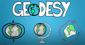
How do scientists study millimeter scale movements of earth’s surface over time? How do we keep all of our clocks synchronized around the world? With geodesy!
Go to ResourceThe cool, rigid outer layer of Earth is highly fractured. In most places, huge chunks or pieces of this rigid outer layer, called plates, are in continuous motion. Plates can range from 50 km to 200km thick. Continental plates are thicker and less dense than oceanic plates that are formed at spreading ridges.
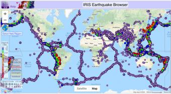
Computer-based visualizations and/or current earthquake reports are used to determine worldwide patterns of earthquake magnitude, depth, and location. These activities use the IRIS Earthquake Browser (IEB; ds.iris.edu/ieb) and are designed to stimulate interest in global earthquake patterns and their causes. This activity provides a natural transition to teaching plate tectonics.
Go to Resource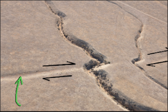
This interactive activity provides three options to demonstrate the geometry of faults (normal, reverse, and strike-slip) and fault displacements with 3-D models. Fault models aid in the visualization and understanding of how faults are created and move because the instructor and their learners can manipulate a 3-D model for a hands-on experience.
Go to Resource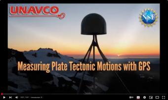
This animation shows how high-precision GPS networks help us understand plate tectonic motions and earthquake hazards around the world, with a focus on the Western United States. Developed for the Geodesy Tools for Societal Issues (GETSI) project with funding from the National Science Foundation.
Go to Resource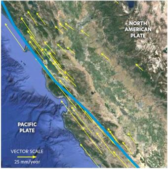
Tectonic plates are constantly moving, and GPS instruments help scientists measure this motion, identifying plate boundaries, deformation zones, and earthquake hazards, with rapidly changing regions being at higher seismic risk. This triad of activities engages learners in exploring authentic GPS data, using hand movements to model plate boundaries, creating vectors to analyze motion, and examining real-world GPS data to study deformation and earthquake risks in the western U.S. and Alaska. By interpreting data, role-playing geoscience careers, and learning about ShakeAlert, learners develop key skills in seismology, geodesy, and hazard preparedness while understanding the risks earthquakes pose to over 143 million people in the U.S.
Go to Resource
In this activity, learners explore ground deformation at and near plate boundaries using hand and body motions, data from GPS and maps. In the 5-minute activity, learners explore the concept of vectors by kinesthetically enacting ground movement using their body and hand movements. In the 20-minute activity, learners model GPS ground motion in different regions and connect deformation to earthquake hazards. In the 45-minute activity learners distinguish between different boundary types by measuring the vectors within tectonic plates and identify regions with higher earthquake hazards, comparing their findings to earthquake shaking potential maps.
Go to Resource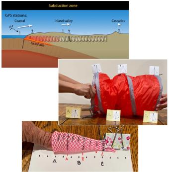
This set of hands-on activities helps students investigate ground deformation and earthquake hazards in the Pacific Northwest using physical models, real-world data, and map analysis. A brief demonstration with a compression spring illustrates how the subduction of the Juan de Fuca plate beneath the North American plate causes varying motion across the region. In longer activities, students measure compression, analyze GPS vector maps, and identify seismic hazard zones. By interpreting real-world data, students develop a deeper understanding of tectonic forces and connect these concepts to earthquake preparedness strategies.
Go to Resource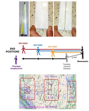
Ground deformation occurs both at plate boundaries and within plates, such as the Basin and Range Province in Nevada, Utah, and California, where extension and rifting can be measured using GPS data. This triad of activities helps learners explore deformation through hands-on modeling with marble tongs, kinesthetic demonstrations of extensional motion, and quantitative analysis of GPS vectors and earthquake hazard maps. Understanding these processes is crucial, as over 143 million people in the U.S. face earthquake risks, and tools like ShakeAlert use GPS data to provide early warnings that can help reduce damage and save lives.
Go to Resource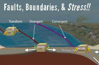
[updated 2021] Earth-science educators, do you ever get asked, "What is stress? Why do faults form in Earth’s crust? or How are faults related to plate boundaries?" This animation describes stress in Earth's outer layer and how it leads to both faults and tectonic plate boundaries.
Go to Resource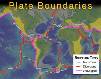
This intermediate-level animation describes what the tectonic (lithospheric) plates are and how they interact. It differentiates between continental and oceanic plates, and between the three major types of boundaries.
Go to Resource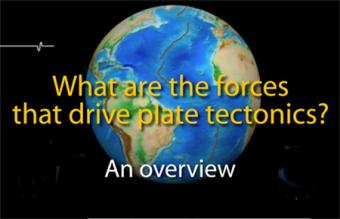
UPDATED (Jan, 2022) - New Ending On Convection
Lithospheric plates are part of a planetary scale thermal convection system. The energy source for plate tectonics is Earth’s internal heat while the forces moving the plates are the “ridge push” and “slab pull” gravity forces.
The Pacific Northwest of the United States is home to several different types of faults that can create small to very large earthquakes. Learn about the three different types of earthquakes, to include an M9 earthquake that occurred along the Cascadia Subduction Zone on January 26, 1700.
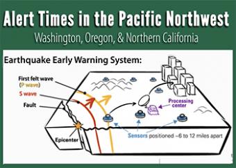
What would you do with seconds to prepare for earthquake shaking? With even a few seconds, the ShakeAlert® Earthquake Early Warning can save lives and reduce injuries by alerting people that an earthquake may cause shaking near you as it triggers automated actions.
Go to Resource
On March 11, 2011, a devastating magnitude-9 earthquake struck off the coast of Tohoku, Japan, where the Pacific Plate dives beneath the Okhotsk Plate. On January 26th, 1700, the West Coast of the United States experienced a similar tsunami-generating megathrust earthquake. An earthquake like this will strike the Cascadia subduction zone again. How can we protect ourselves?
Go to Resource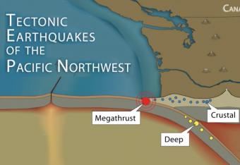
It is common knowledge that the Pacific Northwest can expect a subduction-zone megathrust earthquake in the future. But did you know that there are other types of damaging earthquakes. This animation uses analogies and cartoon block diagrams to teach about the three types of earthquakes.
Go to Resource
This set of hands-on activities helps students investigate ground deformation and earthquake hazards in the Pacific Northwest using physical models, real-world data, and map analysis. A brief demonstration with a compression spring illustrates how the subduction of the Juan de Fuca plate beneath the North American plate causes varying motion across the region. In longer activities, students measure compression, analyze GPS vector maps, and identify seismic hazard zones. By interpreting real-world data, students develop a deeper understanding of tectonic forces and connect these concepts to earthquake preparedness strategies.
Go to Resource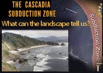
The Cascadia Subduction Zone of the Pacific Northwest is comprised of a collection of major geographic features, including the subducting plate, the subduction plate boundary, the Coast Range, the Puget-Willamette lowlands, and the Cascades Mountain Range.
Go to Resource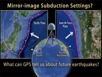
This animation compares Japan's subduction zone at the location of the 2011 earthquake with a mirror-image subduction zone in the Pacific Northwest. There are many similarities.
Go to Resource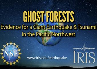
Ghost forests are part of the evidence that a Great earthquake and devastating tsunami occurred last on January 26th, 1700 in the Pacific Northwest. How do we know this?
Go to Resource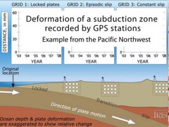
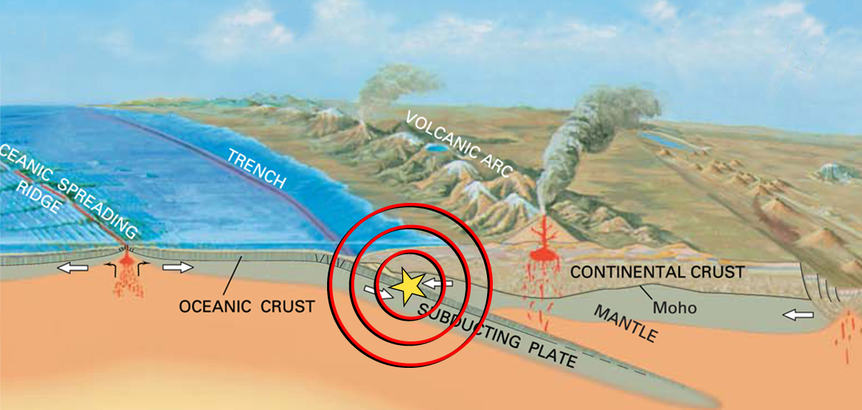
Subduction zones show that there are 3 distinct areas of movement in the overlying plate:
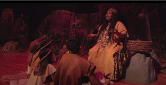
The “Turtle Story” is a Native American story of how earthquakes occur, told by Jacque Tahuka-Nunez who is a tribal descendant of the Acjachemen Nation also known as the Juaneño Band of Mission Indians. This story is derived from the Gabrielina-Tongva Tribe, also known as the San Gabriel Band of Mission Indians in California. This story is catered to children and youth but can be enjoyed by all ages.
Go to Resource
In this activity, learners explore ground deformation at and near plate boundaries using hand and body motions, data from GPS and maps. In the 5-minute activity, learners explore the concept of vectors by kinesthetically enacting ground movement using their body and hand movements. In the 20-minute activity, learners model GPS ground motion in different regions and connect deformation to earthquake hazards. In the 45-minute activity learners distinguish between different boundary types by measuring the vectors within tectonic plates and identify regions with higher earthquake hazards, comparing their findings to earthquake shaking potential maps.
Go to Resource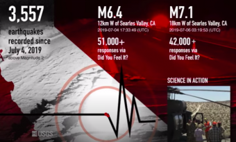
On July 4, 2019, a M6.4 earthquake shook Ridgecrest, California. A M7.1 earthquake followed a little over a day later. These earthquakes struck in the California desert near the towns of Trona and Ridgecrest, which is where the earthquake got its name. Had these earthquakes occurred closer to an urban area, the damage could have been much worse.
Go to Resource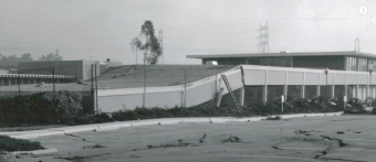
Scientists from the California Geological Survey recall their personal experiences and reactions on the morning of February 9, 1971, when a magnitude 6.5 earthquake struck the San Fernando Valley of Southern California. Their responses illuminate the human dimension of earthquake hazards and emphasize the importance of preparedness for all Californians.
Go to Resource
Ground deformation occurs both at plate boundaries and within plates, such as the Basin and Range Province in Nevada, Utah, and California, where extension and rifting can be measured using GPS data. This triad of activities helps learners explore deformation through hands-on modeling with marble tongs, kinesthetic demonstrations of extensional motion, and quantitative analysis of GPS vectors and earthquake hazard maps. Understanding these processes is crucial, as over 143 million people in the U.S. face earthquake risks, and tools like ShakeAlert use GPS data to provide early warnings that can help reduce damage and save lives.
Go to Resource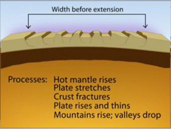
Over most of the last 30 million years, movement of hot mantle beneath the region caused the surface to dome up and then partially collapse under its own weight, as it pulled apart. Currently, there is very little actual stretching going on, and the small amount is concentrated on the Western and Eastern edges of the Basin and Range.
Go to Resource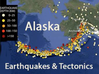
Alaskan tectonics are dominated by the Pacific-North American plates. The megathrust boundary between the plates results in both the 4,000-km-long Aleutian Trench and in the arc of active volcanoes that lie subparallel to the trench.
Go to Resource
Tectonic plates are constantly moving, and GPS instruments help scientists measure this motion, identifying plate boundaries, deformation zones, and earthquake hazards, with rapidly changing regions being at higher seismic risk. This triad of activities engages learners in exploring authentic GPS data, using hand movements to model plate boundaries, creating vectors to analyze motion, and examining real-world GPS data to study deformation and earthquake risks in the western U.S. and Alaska. By interpreting data, role-playing geoscience careers, and learning about ShakeAlert, learners develop key skills in seismology, geodesy, and hazard preparedness while understanding the risks earthquakes pose to over 143 million people in the U.S.
Go to Resource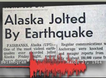
The 1964 Great Alaska Earthquake occurred on Good Friday, March 27th. Liquefaction in and around Anchorage tore the land apart. At magnitude 9.2, it was the second largest quake ever recorded by seismometers.
Go to ResourceWe encourage the reuse and dissemination of the material on this site as long as attribution is retained. To this end the material on this site, unless otherwise noted, is offered under Creative Commons Attribution (CC BY 4.0) license
