
4min 40s Novice Spanish
How does ShakeAlert work and how can it be used?
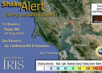
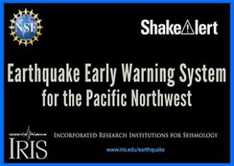
ShakeAlert (www.shakealert.org) is an experimental earthquake early warning system that can give vital time to get to safety after an earthquake occurs. This animation demonstrates how ShakeAlert works by showing how P & S waves are used to locate and measure earthquakes, then send notice to your location about arrival times of potentially damaging waves. The 2014 M6 Napa earthquake showed how even a few seconds can be life saving. The animation also shows how ShakeAlert would work for a large M7.8 earthquake on the southern San Andreas fault.
Animation based on: ShakeAlert (http://www.shakealert.org, earthquake early warning system) and ShakeOut (http://www.shakeout.org an annual earthquake drill).
Made by IRIS in collaboration with the University of Portland, UC Berkeley, Southern California Earthquake Center (SCEC), and US Geological Survey.
CLOSED CAPTIONING: A .srt file is included with the download. Use an appropriate media player to utilize captioning.
ShakeAlert works by
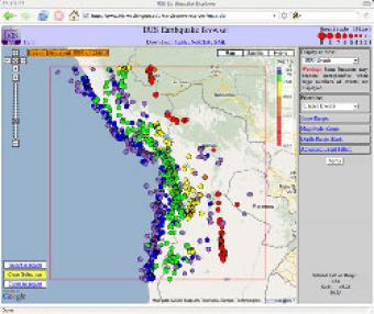
The IRIS Earthquake Browser (IEB) is an interactive tool for exploring millions of seismic event epicenters (normally earthquakes) on a map of the world. Selections of up to 5000 events can also be viewed in 3D and freely rotated with the 3D Viewer companion tool.
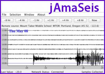
jAmaSeis is a free, java-based program that allows users to obtain and display seismic data in real-time from either a local instrument or from remote stations.
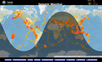
A beautiful map of the latest earthquakes in near-real time. The map also provides links to related resources, news, and connections to 3D maps.
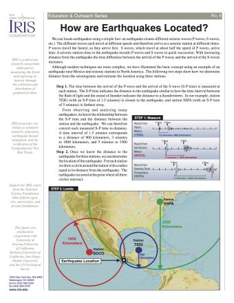
Knowing precisely where an earthquake occurred is an important piece of scientific information. It can help seismologists identify and map seismic hazards. It is also a fundamental piece of information necessary for facilitating studies of Earth's internal structures. This fact sheet provides an overview of the S-P process to locate an earthquake.
NOTE: Out of stock; self-printing only.
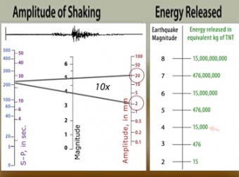
The "moment magnitude" scale has replaced the Richter scale for large earthquakes. Scientists have developed far-more sensitive seismometers that, with faster computers, have enabled them to record & interpret a broader spectrum of seismic signals than was possible in the 1930's, when the Richter magnitude was developed. Find out what scientists learn from seismograms.
ShakeAlert (www.shakealert.org) is an experimental earthquake early warning system (EEW) being tested in the seismically vulnerable West Coast of the United States. This animation shows how ShakeAlert worked for the Napa earthquake, and how it could work for a large M7.8 hypothetical earthquake in Southern California.
On March 11, 2011, a devastating magnitude-9 earthquake struck off the coast of Tohoku, Japan, where the Pacific Plate dives beneath the Okhotsk Plate. On January 26th, 1700, the West Coast of the United States experienced a similar tsunami-generating megathrust earthquake. An earthquake like this will strike the Cascadia subduction zone again. How can we protect ourselves?
We encourage the reuse and dissemination of the material on this site as long as attribution is retained. To this end the material on this site, unless otherwise noted, is offered under Creative Commons Attribution (CC BY 4.0) license
