Advanced
The goal in our work is to make use of all pertinent data at a multitude of scales. The largest scale is mega-regional data, such as the plate tectonic history and paleogeographic maps. We also want data near to or within our study area – more local data - such as topography and surface geology. Local data include all types of surface observations and measurements and in local subsurface data, especially within our study area. This can give us information on lithology, geologic ages (microfossils), geochemical properties, temperature as a function of depth, etc. In the exercise, you will briefly consider the play elements for fifteen (15) offshore blocks in the Gippsland Basin, with the goal to gain information to place bids on some of these blocks.
At the end of this lesson, the student should be able to:
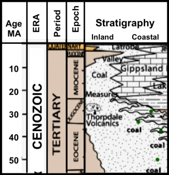
This short course takes a brief look at what happens in the early stages of field exploration in the petroleum industry. The Gippsland Basin, offshore Australia, is the field example, and we start with a look prior to the first offshore licensing round of the field. Throughout the course, we will progress to the stage of management review of a wildcat well.
We encourage the reuse and dissemination of the material on this site as long as attribution is retained. To this end the material on this site, unless otherwise noted, is offered under Creative Commons Attribution (CC BY 4.0) license