
Novice
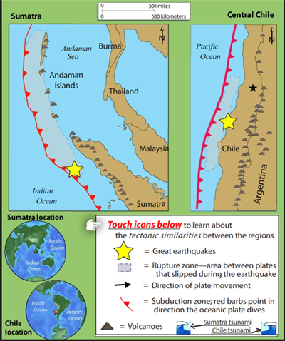
How is Chile's subduction zone like Sumatra's?
Learn how Chile's tectonic setting and megathrust earthquake of 2010 is similar to the catastrophic earthquake in Sumatra in 2004 by touching icons on this interactive map. Includes, location of Great earthquakes, volcanoes, direction of plate movement, subduction zone, rupture zone and tsunami extent.
The tabs above link to related interactives and animations.
VIEW the interactive in a separate tab, by clicking on "Open Resource" then scroll over named features. (Note some browsers lack the plugins for rollovers.)
IRIS may be discontinuing these interactive animations in 2020. This file is an HTML5 file that uses a browser to view.
What do these subduction zones have in common?
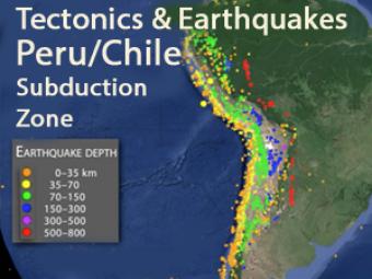
This animation explores three major mechanisms for earthquakes in South America due to the interaction of the Nazca and South American plates.
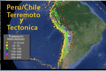
Más de una cuarta parte de los terremotos más significativos de todo el mundo, magnitud 8 o mayores, se han producido en el oeste de Sudamérica. Es el lugar de origen del megaterremoto de magnitud 9,5 ocurrido en Chile en 1960, siendo este el terremoto más grande jamás registrado, y con una serie de terremotos generados por procesos tectónicos de placa e intra-placa.
We encourage the reuse and dissemination of the material on this site as long as attribution is retained. To this end the material on this site, unless otherwise noted, is offered under Creative Commons Attribution (CC BY 4.0) license
