
2min 8s Novice
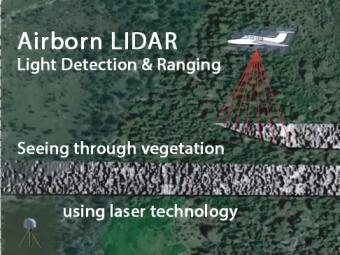
Airborne LIDAR is an optical remote sensing tool that uses laser pulses to measure the precise distance to the ground. The airplane-mounted laser range-finding system, transmits and receives data, which are precisely located using a highly sensitive GPS receiver. Computer-generated images reveal hidden faults not seen through the vegetation. An example from near Lake Tahoe reveals previously unknown fault cross cutting morrains.
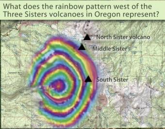
Between 1997-2001 the ground around the Three Sisters Volcanoes in Oregon bulged indicating magma was rising. This bulge was detected using InSAR. InSAR stands for Interferometric Synthetic Aperture Radar. Satellites record images of the Earth's surface, and these images can be combined to show subtle movements of the ground surface, called deformation.
We encourage the reuse and dissemination of the material on this site as long as attribution is retained. To this end the material on this site, unless otherwise noted, is offered under Creative Commons Attribution (CC BY 4.0) license
