
10min 31s Novice
How can we improve earthquake and tsunami warnings?
The March 11, 2011 earthquake and tsunami was a tragedy. Research carried out since that earthquake happened has revealed ways in which earthquake and tsunami alerts can be sent much more quickly, by understanding how energy is stored between plates in a subduction zone, and how that energy is released.
Lessons from the 2011 Tohoku-oki earthquake are being applied to earthquake and tsunami warning systems worldwide.
Scientific lessons learned and described here include:
Scientific lessons learned and described here include:
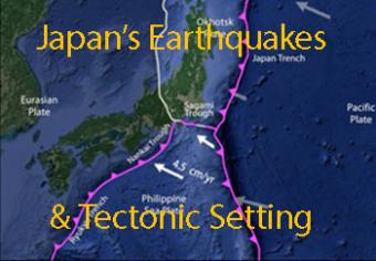
Japan has more measurable earthquakes than any other country and has over 100 active volcanoes. These both result from Japan being wedged among four major tectonic plates. The tectonics are complicated, but in this animation we attempt to look at the basic mechanics of the region. We focus on two famous earthquakes: the 1995 Kobe (Great Hanshin) earthquake and the 2011 Tohoku Oki earthquake.
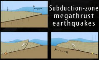
Subduction-zone megathrust earthquakes, the most powerful earthquakes in the world, can produce tsunamis through a variety of structures that are missed by simple models including: fault boundary rupture, deformation of overlying plate, splay faults and landslides. From a hazards viewpoint, it is critical to remember that tsunamis are multiple waves that often arrive on shore for many hours after the initial wave.
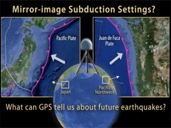
This animation compares Japan's subduction zone at the location of the 2011 earthquake with a mirror-image subduction zone in the Pacific Northwest. There are many similarities.
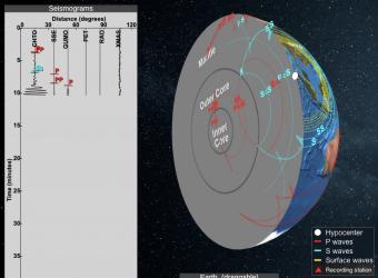
Seismic Waves is a browser-based tool to visualize the propagation of seismic waves from historic earthquakes through Earth’s interior and around its surface. Easy-to-use controls speed-up, slow-down, or reverse the wave propagation. By carefully examining these seismic wave fronts and their propagation, the Seismic Waves tool illustrates how earthquakes can provide evidence that allows us to infer Earth’s interior structure.
We encourage the reuse and dissemination of the material on this site as long as attribution is retained. To this end the material on this site, unless otherwise noted, is offered under Creative Commons Attribution (CC BY 4.0) license
