
9min 20s Novice Spanish Spanish
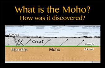
How was it discovered?
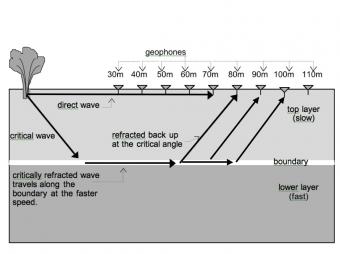
Without understanding what it is, we often hear the phrase “down to the Moho”, meaning very very deep. The Mohorovicic Discontinuity, commonly called the “Moho” is recognized as the boundary zone between Earth's crust and the mantle.
This boundary marks a change in seismic-wave velocity from the crust to the uppermost mantle within the (lithospheric) plate. This boundary was discovered by Andrija Mohorovičić, a Croatian meteorologist-turned seismologist, after an earthquake in Croatia in 1909.
This animation discusses the history of the discovery as well as the logic behind it.
Spoiler Alert: It is about Snell’s Law.
CLOSED CAPTIONING: A .srt file is included with the downloiad. Use appropriate media player to utilize captioning.
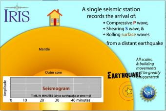
Seismic waves travel through the earth to a single seismic station. Scale and movement of the seismic station are greatly exaggerated to depict the relative motion recorded by the seismogram as P, S, and surface waves arrive.
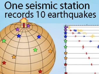
A gridded sphere is used to show:
1) the seismic stations don't need to be lined up longitudinally to create travel-time curves,
as they appear in the first animation, and
2) a single station records widely separated earthquakes that plot on the travel-time curves.
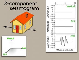
We use exaggerated motion of a building (seismic station) to show how the ground moves during an earthquake, and why it is important to measure seismic waves using 3 components: vertical, N-S, and E-W. Before showing an actual distant earthquake, we break down the three axes of movement to clarify the 3 seismograms.
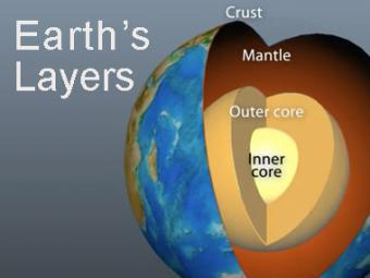
The Earth has 3 main layers based on chemical composition: crust, mantle, and core. Other layers are defined by physical characteristics due to pressure and temperature changes. This animation tells how the layers were discovered, what the layers are, and a bit about how the crust differs from the tectonic (lithospheric) plates, a distinction confused by many.
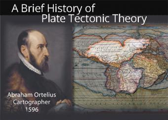
The "Father of Plate Tectonics", Alfred Wegener wasn't recognized when he proposed "Continental Drift" in 1912. It would take another 50 years to be accepted. And yet, in the year 1596 the process was already considered by cartographer Abraham Ortelius. This animation gives an overview of the most-recognized proponents (and opponents) of Plate Tectonics Theory up into the 1960's.
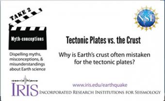
People often use the terms crust and tectonic plates interchangeably. It can be confusing because they are paired, and yet they are distinct from each other.
Students work first in small groups, and then as a whole class to compare predicted seismic wave travel times, generated by students from a scaled Earth model, to observed seismic data from a recent earthquakes. This activity uses models, real data and emphasizes the process of science.
Like other waves, seismic waves obey the laws of physics. In this activity Physics students have the opportunity to apply their understanding of the basic concepts of waves (e.g. reflection, refraction and transmission of energy) as they examine seismic data to determine how far it is from the surface to the bedrock.
We encourage the reuse and dissemination of the material on this site as long as attribution is retained. To this end the material on this site, unless otherwise noted, is offered under Creative Commons Attribution (CC BY 4.0) license
