
Novice
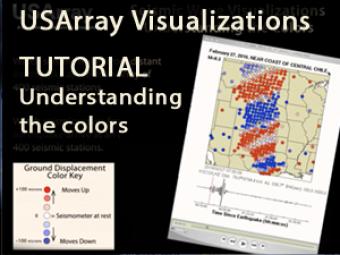
As earthquake waves travel along the surface of the Earth, they cause the ground to move. The ground motions can be captured and displayed as a movie, providing a visual demonstration of these often indiscernible movements. In this sample, red indicates upward vertical motion of the ground vs. blue which indicates downward motion.
Ground motion visualizations are made after large earthquakes and can be found through our "Data Product" link or by going to: http://ds.iris.edu/ds/products/usarraygmv/
CLOSED CAPTIONING: A .srt file is included with the download. Use an appropriate media player to utilize captioning.
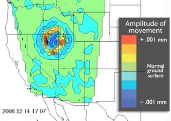
Data visualization of the data generated by over 400 seismograph stations in response to the February 21, 2008 earthquake in Wells, NV.

Working in both small groups and as a whole class, students investigate the classic Earth science analogy: "Seismic waves radiate outward from an earthquake's epicenter like ripples on water". A discrepant image connects the unfamiliar concept of the spreading out of seismic waves to the more familiar scenario of ripples on water radiating outwards in all directions after a droplet falls onto a pool.
USArray Ground Motion Visualizations (GMVs) use real data to show seismic waves sweep across the USArray network of seismic stations. Watch how seismic waves from earthquakes in the US and around the world cause the ground to move at each seismometer.
We encourage the reuse and dissemination of the material on this site as long as attribution is retained. To this end the material on this site, unless otherwise noted, is offered under Creative Commons Attribution (CC BY 4.0) license
