GPS Graphs Subduction-zone Slip-stick Motion

37s Novice

What is slip-stick movement in a subduction zone?

This animation shows a closeup of the movement of the middle GPS station in the animation titled: GPS Records Variable Deformation across a Subduction Zone Here we see the station fixed to the ground which is moving northeast on an approximately 14-month cycle before sliding back accompanied by a gentle seismic shaking shown in the seismogram. ETS describes a particular type of pattern observed within convergent boundaries characterised by aseismic slip with a reversal of direction of the ongoing tectonic plate movement in the same region of the local megathrust accompanied by non-earthquake-like tremors.

Keypoints:

  • Inboard of trench subduction zones often have a slip-stick portion of the contact between the plates
  • This area isn't as tightly locked as the leading edge of the overlying plate
  • Episodic release of the stress occurs on a periodic basis. 
  • Common in subduction zones

Related Animations

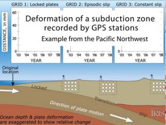
Subduction zones show that there are 3 distinct areas of movement in the overlying plate:

  1. constant movement above the locked leading edge,
  2. see-saw pattern of back-&-forth movement above a zone that alternately locks then slips, and
  3. no movement far inland above the deeper part of the diving oceanic plate.
Animation Novice

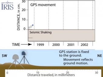
GPS can record the movement of the leading edge of the overlying continental plate in a subduction zone. The plates are locked and the overlying plate is forced back. When friction is overcome and strain is released, the GPS receiver will snap back toward its original position. 

Animation Novice

We encourage the reuse and dissemination of the material on this site as long as attribution is retained. To this end the material on this site, unless otherwise noted, is offered under Creative Commons Attribution (CC BY 4.0) license