ShakeAlert Gets a Boost with GPS Technology

Novice Spanish

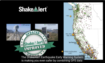
ShakeAlert® Gets a Boost with GPS Technology | What you need to know

ShakeAlert® Earthquake Early Warning gets even better by including GPS technology with seismic data for better estimation of major earthquakes. This animation briefly discusses how ongoing ground movement can recognize and alert the public that the magnitude has been increased.
 
Youtube version: Click on "Watch Embedded Video"


CLOSED CAPTIONING: .srt file is included with the download. Use the appropriate media player to utilize captioning.
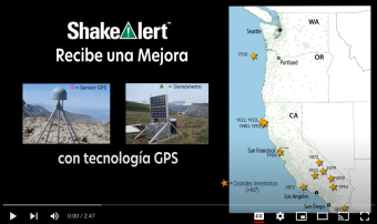
Keypoints:

  • The ShakeAlert Earthquake Early Warning System combines GPS data and Seismic data.
  • During a major earthquake, GPS sensors continuously measure the displacement of the ground.
  • GPS sensors enable the ShakeAlert system to estimate the magnitude of major and great earthquakes more accurately.
  • GPS sensors are anchored to the ground; the sensors move as the ground moves.
  • GPS sensors will measure large ground movements that will occur during a Cascadia subduction zone earthquake, similar to the 2011 magnitude 9.1 earthquake in Japan which caused the land to shift eastward 2.4 meters during its earthquake.
  • GPS data result in alerts being expanded to broader areas.
  • If you feel an earthquake, remember to Drop, Cover, and Hold On. Visit www.ShakeAlert.org to learn more.


We encourage the reuse and dissemination of the material on this site as long as attribution is retained. To this end the material on this site, unless otherwise noted, is offered under Creative Commons Attribution (CC BY 4.0) license