About SPUD

SPUD Version 3.0

The Searchable Product Depository (SPUD) is the IRIS DMC's primary data product management system. Complementing the DMC's SEED and assembled data archives, which contain time series recordings, the SPUD system primarily contains derivative data products of other types (images, movies, etc.) created either at the DMC or by members of the community.

For users SPUD is the query and access point for these products. The web interfaces allow users to search for products using customized queries across product and event details. Users can search across all product types at once or within specific product types. SPUD also has web service interfaces for programmatic discovery and access to the data products.

If any products from SPUD are used in your research please be sure to cite the identified author of the product and the IRIS DMS [Citation Information].
About Ground Motion Visualization Products

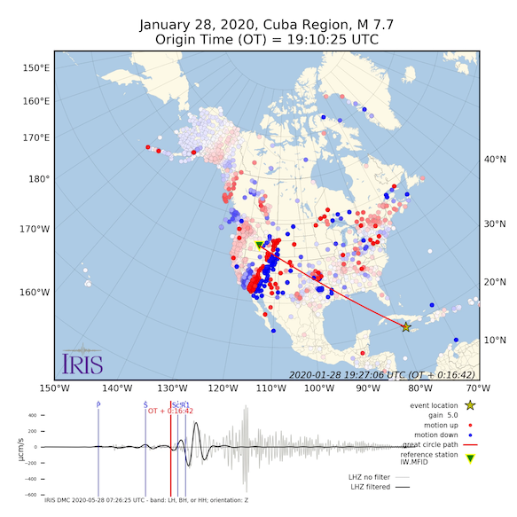
The Ground Motion Visualization (GMV) illustrates how seismic waves travel away from the earthquake location by depicting the recorded wave amplitudes at each seismic station location using colored symbols. For more information on GMVs visit the GMV product page.

Two types of GMVs are produced:

  • Vertical-component GMV:
    Produced for US events of magnitude 5.5 or larger and global events of magnitude 6 or larger. The symbol colors represent the amplitude of the vertical ground motion, as detected by the station's seismometer.
  • 3-Component GMV:
    Produced only for events with magnitude 7 and larger use 'tailed' symbols to show direction and amplitude of the normalized horizontal motion. Symbol colors also represent the amplitude of the vertical ground motion, as detected by the station's seismometer.

This product is automatically generated without human review.

Citing Ground Motion Visualization Products

If you use GMVs in publications, please cite according to the instructions at:

http://ds.iris.edu/ds/products/gmv/#citation

Credits:

— Chuck Ammon, Professor of Geosciences at Penn State’s original concept and visualizations. Read more
— Bob Woodward at IRIS - adapted the visualization code to MATLAB

When citing this GMV page please use the Digital Object Identifier (DOI):

doi:10.17611/DP/1583035

GMV Help

The page displays information for individual Ground Motion Visualizations.

GMV for MI 7.2 MINDANAO, PHILIPPINE ISLANDS icon
Event
Date-Time (UTC): 2013-10-15 00:12:32
Location: MINDANAO, PHILIPPINES
Latitude, Longitude: 9.880 °, 124.117 °
Magnitude: 7.1 mww (us)
Depth: 19.04 km
Author: us
Catalog, Contributor: NEIC PDE, us
Related Products:
Product Trigger Origin
Date-Time (UTC): 2013-10-15 00:12:37
Location: MINDANAO, PHILIPPINE ISLANDS
Latitude, Longitude: 9.765 °, 124.022 °
Magnitude: 7.2 MI (NEIC)
Depth: 56.8 km
Author: NEIC
Catalog, Contributor: NEIC PDE, NEIC ALERT


Array Event Location (azimuthal equidistant projection)


Related Links
Contributions