Instructional video shows how to conduct 5-step student activity to build gum-drop GPS station, learn how GPS works, then model and graph the GPS movement.
Part A, covered the steps to build and use a gumdrop GPS station.
In this video, Part B, students learn how to read time-series plots and understand how we know the ground is moving.
Demonstration by Roger Groom, Mount Tabor Middle School, Portland OR. Winner of the 2009 NAGT Earth science teacher award.
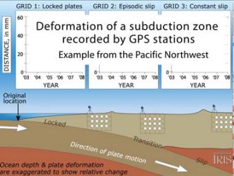
Subduction zones show that there are 3 distinct areas of movement in the overlying plate:
We encourage the reuse and dissemination of the material on this site as long as attribution is retained. To this end the material on this site, unless otherwise noted, is offered under Creative Commons Attribution (CC BY 4.0) license