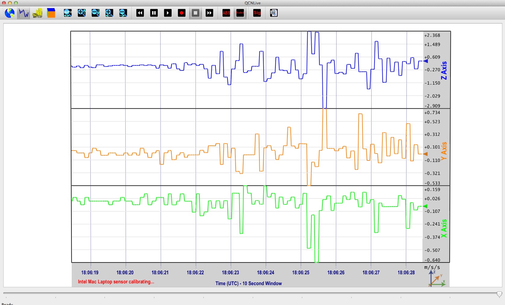
QCNLive is interactive software developed for hands-on education about Earthquake Seismology. There are several modules within QCNLive for learning about earthquake vibrations and where earthquakes occur. The software measures and plots real-time motions acquired from several types of internal and/or external Micro-Electro-Mechanical System (MEMS).
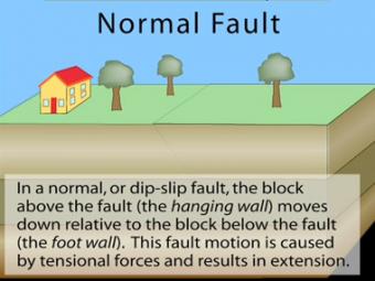
In a normal fault, the block above the fault moves down relative to the block below the fault. This fault motion is caused by extensional forces and results in extension. Other names: normal-slip fault, tensional fault or gravity fault. Examples: Sierra Nevada/Owens Valley; Basin & Range faults.
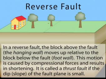
In a reverse fault, the block above the fault moves up relative to the block below the fault. This fault motion is caused by compressional forces and results in shortening. A reverse fault is called a thrust fault if the dip of the fault plane is small. Other names: thrust fault, reverse-slip fault or compressional fault]. Examples: Rocky Mountains, Himalayas.
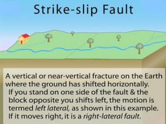
In a strike-slip fault, the movement of blocks along a fault is horizontal. The fault motion of a strike-slip fault is caused by shearing forces. Other names: transcurrent fault, lateral fault, tear fault or wrench fault. Examples: San Andreas Fault, California; Anatolian Fault, Turkey.
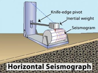
Animation of the principles of a drum-style horizontal seismograph station that records back- and-forth (N-S, E-W) movement.
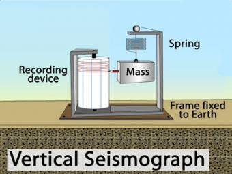
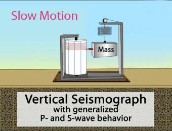
Animation of the principles of a drum-style vertical seismograph station that records up-and-down movement.
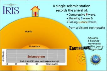
Seismic waves travel through the earth to a single seismic station. Scale and movement of the seismic station are greatly exaggerated to depict the relative motion recorded by the seismogram as P, S, and surface waves arrive.
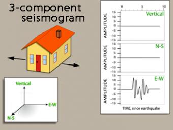
We use exaggerated motion of a building (seismic station) to show how the ground moves during an earthquake, and why it is important to measure seismic waves using 3 components: vertical, N-S, and E-W. Before showing an actual distant earthquake, we break down the three axes of movement to clarify the 3 seismograms.
Animation of the principles of a drum-style vertical seismograph station that records up-and-down movement.
A beautiful map of the latest earthquakes in near-real time. The map also provides links to related resources, news, and connections to 3D maps.
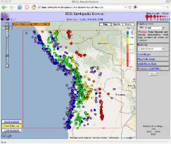
The IRIS Earthquake Browser (IEB) is an interactive tool for exploring millions of seismic event epicenters (normally earthquakes) on a map of the world. Selections of up to 5000 events can also be viewed in 3D and freely rotated with the 3D Viewer companion tool.
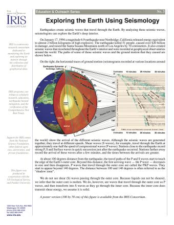
Earthquakes create seismic waves that travel through the Earth. By analyzing these seismic waves, seismologists can explore the Earth's deep interior. This fact sheet uses data from the 1994 magnitude 6.9 earthquake near Northridge, California to illustrate both this process and Earth's interior structure.
NOTE: Out of Stock; self-printing only.
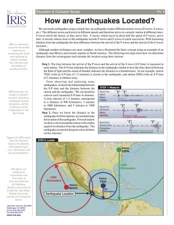
Knowing precisely where an earthquake occurred is an important piece of scientific information. It can help seismologists identify and map seismic hazards. It is also a fundamental piece of information necessary for facilitating studies of Earth's internal structures. This fact sheet provides an overview of the S-P process to locate an earthquake.
NOTE: Out of stock; self-printing only.
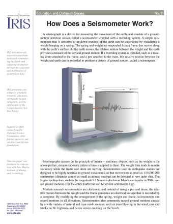
A seismograph is a device for measuring the movement of the earth, and consists of a ground-motion detection sensor, called a seismometer, coupled with a recording system. This fact sheet provides an overview of the basic components of a seismometer and physical science principles behind its operation.
NOTE: Out of Stock; self-printing only.
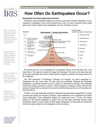
Earth is an active place and earthquakes are always happening somewhere. In fact, the National Earthquake Information Center locates about 12,000-14,000 earthquakes each year! This fact sheet illustrates information on the frequency of earthquakes of various magnitudes, along with details on the effects of earthquakes and the equivalent energy release.
NOTE: Out of stock; self-printing only.
Seismic waves from earthquakes ricochet throughout Earth's interior and are recorded at geophysical observatories around the world. The paths of some of those seismic waves and the ground motion that they caused are used by seismologists to illuminate Earth's deep interior.
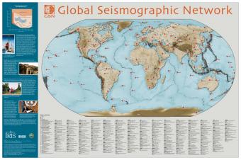
The Global Seismographic Network (GSN) consisting of more than 125 seismic stations provides data for scientific research, education, earthquake hazard mitigation, tsunami warning, and the international monitoring system for the Comprehensive Nuclear Test-Ban Treaty.
We encourage the reuse and dissemination of the material on this site as long as attribution is retained. To this end the material on this site, unless otherwise noted, is offered under Creative Commons Attribution (CC BY 4.0) license