


Date: April 14, 2016 6min 32s Novice
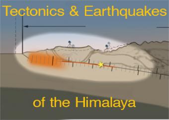
What caused the April 25, 2015 Nepal Earthquake?
Regional compression produces broadly distributed earthquakes north of the 2,900-km-long Himalayan plate boundary. However, the historical earthquake record indicates that the largest earthquakes, shown by their rupture areas, occur on the shallow portion of the megathrust boundary.
This animation discusses the evolution of the Himalaya in a broad tectonic context and focusses more closely on the 2015 Nepal earthquake.
It is worth it to watch video footage from a surveillance camera, in concert with a graph of GPS motion that occurs at 2min 55sec (created by UNAVCO).
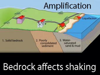
The Kathmandu Basin is a broad valley in the foothills leading to the high Himalayas. This valley was formerly the site of a lake within which up to 600 meters of thickness of river delta and lake sediment accumulated. Compared to bedrock around and beneath the basin, seismic waves from the Gorkha earthquake caused these lake sediments to shake like Jello in a bowl.
CLOSED CAPTIONING: A .srt file is included with the downloiad. Use appropriate media player to utilize captioning.
An IRIS Teachable Moment PowerPoint presentation created for this earthquake can be downloaded from: www.iris.edu/hq/retm/event/3363.
For more-technical presentations and publications, please visit: ds.iris.edu/ds/nodes/dmc/specialevents/2015/04/25/nepal/.
[It is important to note that although this is a "megathrust" earthquake, it is above sea level thus does not produce tsunamis.]
What caused the April 25, 2015 Nepal earthquake?
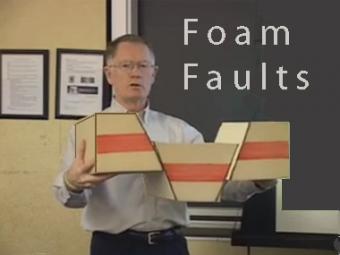
How can I demonstrate plate tectonic principles in the classroom?
Video lecture demonstrates the use of foam faults to demonstrate faults, and a deck of cards to demonstrate folds and fabrics in rock layers. Different types of faults include: normal (extensional) faults; reverse or thrust (compressional) faults; and strike-slip (shearing) faults.
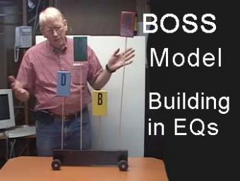
This video lecture shows John Lahr (USGS Seismologist Emeritus) describing the BOSS experiment that models oscillations of different height buildings.
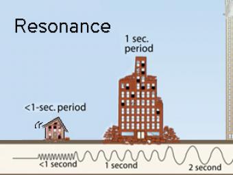
All buildings have a natural period, or resonance, which is the number of seconds it takes for the building to naturally vibrate back and forth. The ground also has a specific resonant frequency. Hard bedrock has higher frequencies softer sediments. If the period of ground motion matches the natural resonance of a building, it will undergo the largest oscillations possible and suffer the greatest damage.
Highly generalized animation reflects the arrivals of P, S, and surface waves to 3 closely spaced buildings. Exaggerated movement of the buildings reflects the relative motion recorded by the seismograms.
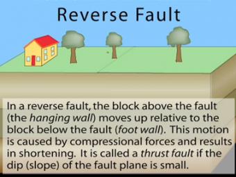
In a reverse fault, the block above the fault moves up relative to the block below the fault. This fault motion is caused by compressional forces and results in shortening. A reverse fault is called a thrust fault if the dip of the fault plane is small. Other names: thrust fault, reverse-slip fault or compressional fault]. Examples: Rocky Mountains, Himalayas.
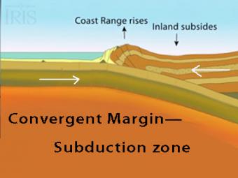
The subduction zone iswhere two tectonic (lithospheric) plates come together, one subducting (diving) beneath the other. The plates are locked together and periodically overcome the friction causing the leading edge of the overlying plate to surge back, lifting a wall of water producting a tsunami.
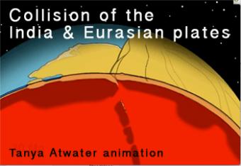
This animation shows a cut-globe view of the continental collision between India and Eurasia from 60 million years ago to present. Many details are drawn reflecting ideas current in about 2006, and are subject to change as research continues.
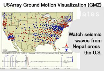
Seismic waves from the 2015 Nepal earthquake move across the United States and are recorded by EarthScope's USArray seismograph stations. The USArray Ground Motion Visualization (GMV) illustrates how seismic waves travel away from the earthquake location by depicting the recorded wave amplitudes at each EarthScope/USArray station location using colored symbols.
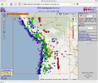
The IRIS Earthquake Browser (IEB) is an interactive tool for exploring millions of seismic event epicenters (normally earthquakes) on a map of the world. Selections of up to 5000 events can also be viewed in 3D and freely rotated with the 3D Viewer companion tool.
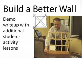
Build a Better wall is an activity developed by FEMA for their "Seismic Sleuths" instructional booklet for students to help with earthquake mitigation. This activity helps students learn how diagonal braces, shear walls, and rigid connections strengthen a structure to carry forces resulting from earthquake shaking.
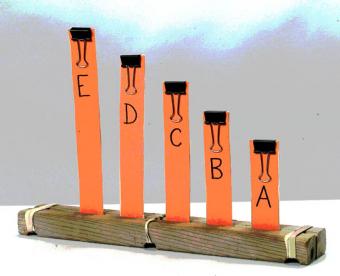
All buildings have a natural frequency of oscillation or resonance frequency. When seismic waves shake the ground beneath a building at its resonance frequency, the structure will begin to sway back and forth. This concept can be demonstrated in the classroom using the BOSS Model Lite as a discrepant event demonstration to engage students in earthquake-engineered buildings.
We encourage the reuse and dissemination of the material on this site as long as attribution is retained. To this end the material on this site, unless otherwise noted, is offered under Creative Commons Attribution (CC BY 4.0) license


