


7min 46s Novice Spanish
How does Mexico's "Earthquake Early Warning" system work?
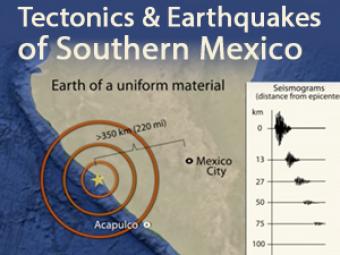
In 1985, a Great, magnitude 8.1 subduction zone earthquake occurred beneath the coast of Michoacan Mexico. Despite the 350-km distance from the earthquake epicenter to Mexico City, most of the 9,500 fatalities occurred there. That earthquake prompted Mexico to develop an earthquake alert system for all of Southern Mexico. This animation describes the tectonic and geologic process that affect the region, including concepts like magnitude, basin amplification, and building resonance.
CLOSED CAPTIONING: A .srt file is included with the downloiad. Use appropriate media player to utilize captioning.
Mexico City was affected by:
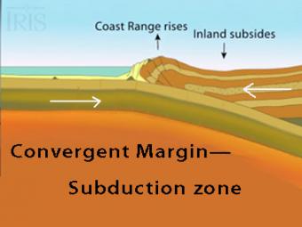
The subduction zone iswhere two tectonic (lithospheric) plates come together, one subducting (diving) beneath the other. The plates are locked together and periodically overcome the friction causing the leading edge of the overlying plate to surge back, lifting a wall of water producting a tsunami.
Oblique view of a highly generalized animation of a subduction zone where an oceanic plate is subducting beneath a continental plate. (See sketch below for parts.) This scenario can happen repeatedly on a 100-500 year cycle. The process which produces a mega-thrust earthquake would generate a tsunami, not depicted here.
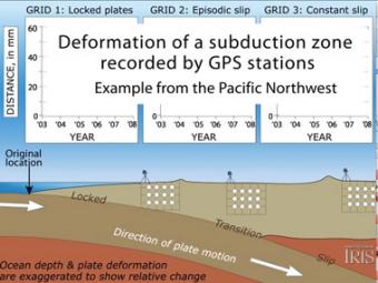
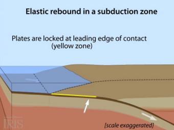
Subduction zones show that there are 3 distinct areas of movement in the overlying plate:
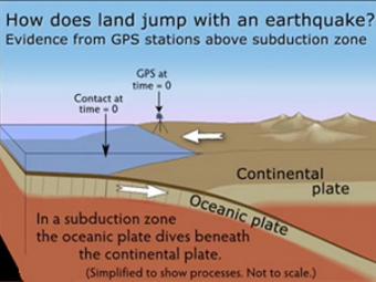
GPS can record the movement of the leading edge of the overlying continental plate in a subduction zone. The plates are locked and the overlying plate is forced back. When friction is overcome and strain is released, the GPS receiver will snap back toward its original position.
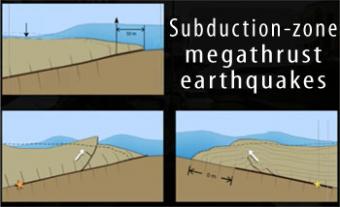
Subduction-zone megathrust earthquakes, the most powerful earthquakes in the world, can produce tsunamis through a variety of structures that are missed by simple models including: fault boundary rupture, deformation of overlying plate, splay faults and landslides. From a hazards viewpoint, it is critical to remember that tsunamis are multiple waves that often arrive on shore for many hours after the initial wave.
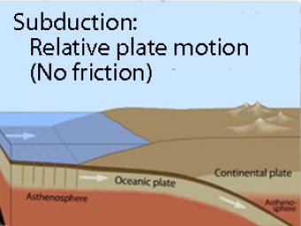
Oblique view of a highly generalized animation of a subduction zone where an oceanic plate is sliding beneath a continental plate with no friction just to show the relative motion between the plates..
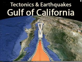
This animation depicts the evolution of the spreading ridge that marks the boundary between the Pacific and North American Tectonic Plates. The on-land part of this submarine spreading ridge extends into Baja California, Mexico and the Imperial Valley of California where it is transitioning from ridge-transform boundary to the continental boundary along the San Andreas fault zone.
We encourage the reuse and dissemination of the material on this site as long as attribution is retained. To this end the material on this site, unless otherwise noted, is offered under Creative Commons Attribution (CC BY 4.0) license


